
Portfolio

Terrestrial LiDAR Scanning
Millimetre-level 3D scanning with the RIEGL VZ-400i for quarries, stockpiles, tunnels, bridges, industrial plants and structural assessment.
The VZ-400i captures dense, registered point clouds fast enough to scan an active site without shutting it down. We deliver volume calculations, as-built models, deformation comparisons between campaigns and full documentation of complex structures where conventional survey cannot reach safely.
Typical applications include stockpile inventory, tunnel and underground works, bridge and structural inspection, plant as-builts and heritage documentation.
Available as a contracted service across the region or as a supplied system with certified training and calibration support from our own laboratory. Request a consultation with our geospatial team.

Aerial LiDAR Surveying
High-density aerial LiDAR for corridors, transmission lines, roads and large-area terrain modelling. We operate the CHC AlphaAir system, delivering classified point clouds, bare-earth digital terrain models and contour data ready for engineering design.
We cover the full workflow: flight planning, ground control, acquisition, processing and delivery in the format your engineering team already uses. You receive survey-grade data, not raw files you still have to solve.
Built for utilities, transmission operators, road authorities and engineering consultancies across the Caribbean and Central America. Available as a contracted service or as equipment supply with full training.
Galileo Instruments has delivered high-precision geospatial technology since 2010. Talk to our geospatial team about your project.

Security and Defense Solutions
Aerial and geospatial technology for operational security: perimeter surveillance, critical infrastructure monitoring, emergency response and situational awareness.
Our defense and security line supports police, civil protection, emergency services, port and border authorities and private operators of critical assets, with platforms and sensors selected for the mission rather than for the catalogue.
We work through the full cycle: needs assessment, system configuration, operator training and certification, and sustained technical support with calibration and maintenance from our own laboratory.
Galileo Instruments has supplied high-precision technology and specialised services in geomatics, geospatial solutions and operational security since 2010. Contact our defense solutions team to discuss requirements under confidentiality.
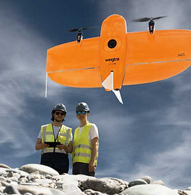
Drone Mapping and Photogrammetry
Fixed-wing VTOL mapping with Wingtra, plus the full photogrammetric processing chain in Pix4D and Agisoft Metashape.
Wingtra covers large areas in a single flight with survey-grade accuracy, taking off and landing vertically where there is no runway. It is the right platform for cadastral mapping, land administration, corridor studies, coastal survey and any project where walking the terrain is slow, expensive or unsafe.
Deliverables include orthomosaics, digital surface and terrain models, contours, volumes and 3D meshes, referenced to the coordinate system your project requires.
We supply the aircraft, the software and the training, and we support the workflow afterwards. Equipment sales, service contracts and technical training available across the Caribbean and Central America.

Precision Agriculture Solutions
Multispectral imaging and analysis for agricultural operations that need to see crop condition before it is visible from the ground.
We supply MicaSense RedEdge multispectral sensors together with the drone platforms and processing software that turn captured imagery into vegetation indices, plant counts, variability maps and prescription layers for variable rate application.
Used in sugarcane, banana, oil palm, rice and large-scale plantation agriculture, where a few days of early detection changes the size of the loss.
We deliver the sensor, the platform, the software and the training as one working system, with technical support and calibration through our own laboratory. Talk to us about a pilot on your own fields.
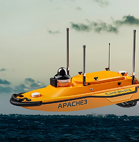
Bathymetric Survey Solutions
Bathymetric survey technology for ports, channels, reservoirs, rivers and coastal works.
We supply and support the instrumentation used to measure what is underwater: depth, channel geometry, sedimentation and volume change over time. For island and coastal economies this is not optional infrastructure work, it is what keeps a channel navigable and a reservoir accountable.
Applications include dredging control and volume verification, port and channel maintenance surveys, reservoir capacity studies, river morphology and coastal erosion monitoring.
As with every line we represent, the equipment comes with training, calibration and regional technical support, not just a shipment. Contact our geospatial team to size the right configuration for your operation.
